Hurricane Earl Comes Very Close to Anguilla
On August 30th, Hurricane Earl came too close for comfort (perhaps 30 miles from Anguilla) and caused flooding, damages to roofs, fencing and, as always with hurricanes, to the island gardens, farms and vegetation.
And right behind it, tracking on almost the same path, was Fiona. Our shelter took in a lot of water, but otherwise made it through the storms.
Read on for some photos, graphics, information and links. Jeff Masters and Wunderground should be bookmarked by anyone interested in weather in general, but is a must site for those interested hurricanes and weather that might affect the Caribbean. (But it covers cyclones and storms in the Pacific and other regions as well.)
Wikipedia has a nice 2010 storm summary with even more photos and information.
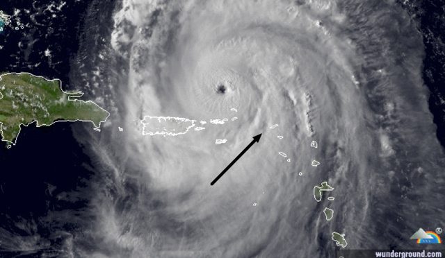
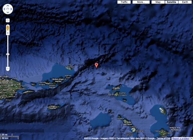
In the image above, Anguilla is shown (pointed to by the arrow), relative to the eye of Earl. Courtesy Wunderground, an excellent weather site. See the full track of Earl further down this page.
This image of Earl was dated August 30, 4:47 p.m. Eastern Daylight Time (EDT) or 20:47 p.m. UTC (Universal Coordinated Time, aka Greenwich Mean Time or GMT). Earl was a category 4 hurricane by this time (well, it was 13 minutes later at 21:00 GMT!).
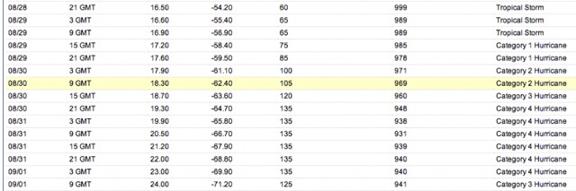
Above, this part of a tracking chart shows some interesting dates, times and locations of Earl. It also shows latitude and longitude coordinates, wind speeds, barometric pressure and hurricane status.
To see any lat/long coordinates on Google maps, go to Google maps and copy/paste or type in “18.30 N, 62.40 W” (without the quote marks). After doing that, for more fun, switch to Satellite or Earth modes; zooming and panning hilarity can then take place.
Looking at the yellow highlighted line, on August 30th, at 9 a.m. GMT, Earl was pretty much at its closest point to Anguilla. It was at Category 2 (105 mph), but was working towards a Cat 3, and following that, became a Cat 4 just about 12 hours later.
The image below shows that 9 a.m. position.
(From a time zone standpoint, 9 a.m. GMT equates to both 5 a.m. Anguilla and Eastern time because August was still in the Daylight Savings Time period — before the "fall" back change to Standard Time.)
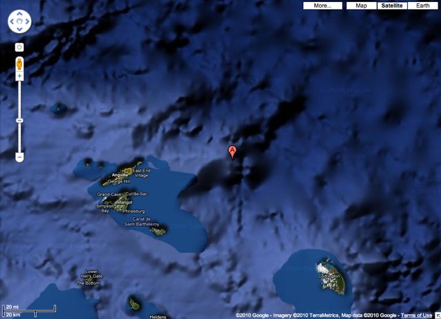
The image above shows Earl at 9 a.m. UTC, 5 a.m. Anguilla/Atlantic and Eastern time. It was tracking to the northwest.
Earl was at 18.30 N, 62.40 W (per the yellow highlighted line in the chart above). To see this in Google maps, type in the coordinates “18.30 N, 62.40 W” (without the quotes).
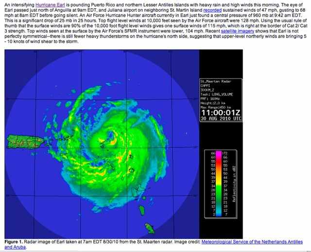
Earl at 11:00 UTC (7:00 a.m. Atlantic and Eastern), shown by Sint Maarten radar. The eye was a bit NE of Anguilla but you can see how the storm was lashing us and Sint Maarten (which is on the center horizontal line.
By the way, we think the best hurricane and storm center around is Wunderground. Be sure to check out their Category 6 blog.
Earl had passed Anguilla, but had intensified up to Category 3. This was still August 30th.
At 3 p.m. GMT (the 15 GMT line on the chart a few images above), or 11 a.m. Anguilla and Eastern time), Earl was was at 18.70 N, 63.60 W. (To see this on Google maps, type in 18.70 N, 63.60 W.)
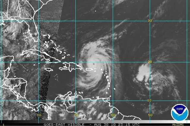
Earl now north of the Virgin Islands on August 30th at 23:15 UTC (7:15 p.m. Atlantic and Eastern).
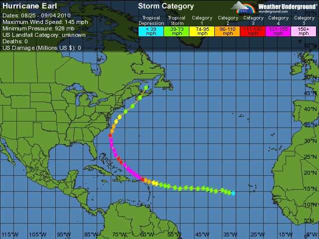
This image shows the track of Hurricane Earl, with color codes representing the Category strength designations.
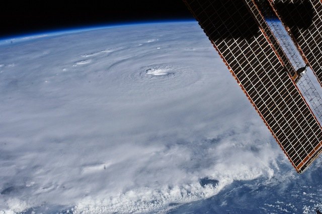
This image shows a magnificent photo of Hurricane Earl taken from the space station on August 30. This and other photos of Earl can be seen from the excellent NASA site, earthobservatory. You can download a full sized image using the link just provided.
The text that accompanies this particular photo is is:
The relatively placid view from the International Space Station belied the potent forces at work in Hurricane Earl as it hovered over the tropical Atlantic Ocean on August 30. With maximum sustained winds of 135 miles (215 kilometers) per hour, the storm was classified as a category 4 on the Saffir-Simpson hurricane scale as it passed north of the Virgin Islands.
In this photograph captured with a digital SLR camera by NASA astronaut Douglas Wheelock, Earl had a distinct eye that spanned about 17 miles (28 kilometers). Most of the storm had a seemingly uniform top, though the bottom edge of the image gives some sense of the towering thunderheads forming over the ocean. The solar panels of the ISS remind us that the sun is still shining, at least on ISS Expedition 24.
Around the time of the photograph on August 30, the National Hurricane Center reported that Earl was centered near latitude 19.3 degrees North, longitude 64.7 degrees West, about 110 miles (180 kilometers) northeast of San Juan, Puerto Rico. The storm was moving west-northwest at 15 miles (24 km) per hour.
On the same day, scientists participating in NASA's Genesis and Rapid Intensification Processes field campaign snapped their own photos of the storm, which you can see here.
"Hurricane Earl is gathering some serious strength," Wheelock wrote from his perch on ISS. "It is incredible what a difference a day makes when you’re dealing with this force of nature. Please keep a watchful eye on this one...not sure if Earl will go quietly into the night like Danielle."
Coordinates latitude and longitude 19.3N, 64.7W would put the center of Earl about 110 miles NE of San Juan, which itself is about 140 miles from Anguilla (but keep in mind the storm was some 300-400 miles wide at times.)
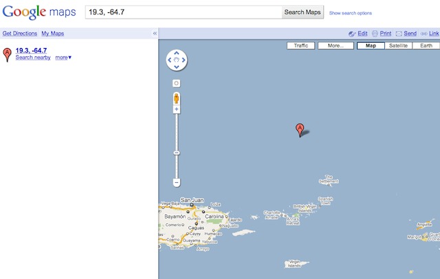
Earl at 19.3N, 64.7W on August 30 after it passed Anguilla and had reached Category 4 status.
Bonus photos (added August 9, 2011):
We found these photos on the Earth Observatory site and decided to add them. Both were taken on August 29th at 14:20 UDT or 10:20 am Anguilla (and Eastern Daylight Time). The first shows Earl as it works its way along the Leeward islands towards Anguilla (yellow circle). The second is an interesting shot showing both Earl and Danielle in the same photo (the approximate location of Anguilla is shown by the yellow arrow). Since both were taken at the same time, consider the first photo a zoomed–in version of the second.
Both hurricanes provided a one–two punch of a ton of rain and waves.
You can go to the EO site and download full sized versions of the files or zoom in on them. Here is the first photo; here is the second.
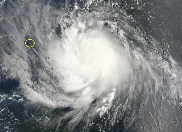
Earl works its way along the Leeward islands towards Anguilla, which is shown by the yellow circle. The next photo was taken at the same time as the above photo; it shows Danielle and Earl.
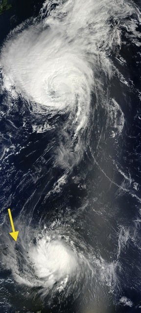
Earl and Danielle in the same photo (the approximate location of Anguilla is shown by the yellow arrow).

